Fletcher's Folly, our hypothetical town in New Jersey, has been zoned in a traditional way. Very little planning was used to connect between zones or the size of area each zone covered. Little thought has been made to use zoning maps to conserve some areas as open space, or developing new town center areas.
 |
 |
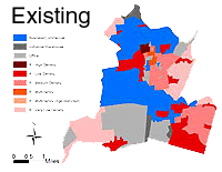
| The existing zoning map for Fletcher's Folly.
Click on the image to enlarge. |
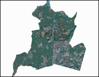
An aerial view of Fletcher's Folly today.
Click on the image for details. |
Zoning map: Note how residential zones are sprawling over the entire municipality More....
Aerial photo: Here is what Fletcher's Folly looks like from the air at the present time. This type of image was taken from an airplane by the New Jersey Department of Environmental Protection and the United States Geological Survey. These air photos are taken for the entire state of New Jersey every 5-10 years and can be valuable tools in assessing how fast the land use of an area is changing over time. More....
Currently, Fletcher's Folly either does not have a town plan or they have not applied long term goals to their zoning map.
Let's look at an alternative - goal-oriented zoning. 
