![[Back]](../../../images/back.gif "[Back]") |
Index | ![[Next]](../../../images/next-red.gif "[Next]") |
Sandy Hook is an approximately 16km long barrier spit extending north from Long Branch in Monmouth County. It terminates in the Sandy Hook unit of Gateway National Recreation Area (GNRA), part of the National Park Service.
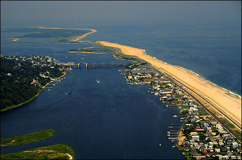 |
| View of Sandy Hook Spit, looking north. The Atlantic Ocean is on the right, Sandy Hook Bay, the Shrewsbury River, and the Navesink River are on the left. Image: Dr. N. Psuty, Rutgers. |
The termination of the seawall in Sandy Hook GNRA poses an interesting management situation for Park Personnel. Diffraction and refraction of waves causes a log-spiral to form downdrift of the seawall, offsetting the shoreline landward for approximately 2km. By the late 1980s this offset had gotten so large that the infrastructure (in this case, the only road accessing the Park) was being threatened. This offset was magnified by persistent erosion from a negative sediment budget, partially resulting from the updrift groinfield in Sea Bright, Monmouth Beach, and Long Branch. The offset area has been dubbed the Critical Zone as it is the narrowest portion (most prone to breech) of Sandy Hook that is not protected by the seawall.
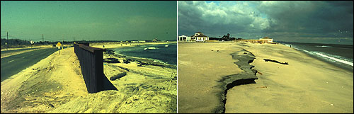 |
| Sheet-pile bulkhead installed to protect the road at Sandy Hook GNRA, 1988, and damage to the parking lot downdrift. Image: Dr. N. Psuty, Rutgers. |
The National Park Service, as part of their goals to protect both access and the natural environment, conducted several beach nourishment projects over the next decade to protect their investment in infrastructure, preserve access, provide a recreational platform, and provide habitat for the endangered piping plover.
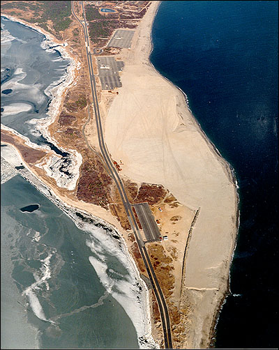 |
| Critical Zone filled by beach nourishment conducted by the US Army Corps of Engineers.Image: Dr. N. Psuty, Rutgers. |
In addition to nourishing the beach, a large artificial dune ridge was also constructed to provide the elevation necessary to protect from storms. The beach nourishment project was expected to last approximately 5 years. The updrift groin field, and net negative sediment budget, means that even though sediment was placed on the beach, the material will continue to erode and maintenance of the fill will continue to be necessary to maintain the beach.
Without the mass of beach and dune, storms and persistent erosion can threaten or damage infrastructure and natural areas.
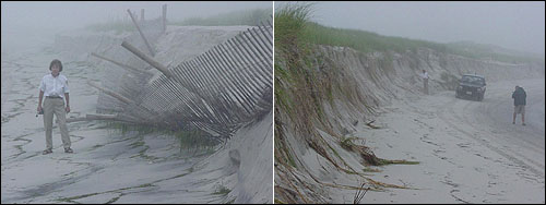 |
| Island Beach State Park (Ocean County), after a recent storm in 2003. The dune, while scarped, has protected inland areas. Given adequate sediment and a period of quiescence, this dune and beach may recover over time. Image: Rob Auermuller, IBSP. |
Additional Case Study: Borough of Mantoloking
Smart Growth Gateway has a detailed Case Study for the Borough of Mantoloking with regards to dune ordinances and beach maintenance. It provides, in detail, rules and regulations for dune and beach use and construction and is recommended if you wish to obtain more information about protecting a beach from coastal hazards. You may also visit our toolbox for more information and reference material.
|
Index | |